Throughout the Dominion Land Survey, there were many different types of instruments available to the surveyors. During the decades of surveying the technology advanced, making surveys more precise with each change.
The instruments shown in the following images and described in the explanations below illustrate these advances. At first, surveys were done with physical measures like chains and metal lengths of tape. Instruments for angular measurement, such as theodolite, were much more sophisticated and accurate. Then, surveyors incorporated invisible means to measure with sound waves and light, which made for great accuracy and speed. Finally, computers and satellite have taken over. But it was the airplane that made the greatest revolution by carrying a camera or pulse emitter to record and measure the earth’s surface.
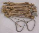
Gunter’s chain was invented by Edmund Gunter, a clergyman and mathematician who lived from 1581-1626. The chain was divided into 100 links, marked off into groups of 10 by brass rings and was 66 feet long. The chain had 198 points where friction wear would occur. This wear would cause the chain to change in length, making measurements with the chain more incorrect the more the chain was used. Gunter's chain would also contract slightly in cold temperatures and expand in warmer ones.
To use the chain, a surveyor was assisted by a chainman who held a ranging rod (usually prominently coloured) on the ground at the destination point. Starting at the originating point the chain was laid out towards the ranging rod, and then the chainman would make the chain perfectly straight and point it directly at the ranging rod. This “ranging” process was repeated until the destination rod was reached, then the surveyor noted how many full lengths (chains) had been laid. The process was surprisingly accurate and required only very low technology.
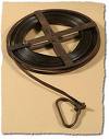
The steel-tape “chain” was used in a similar fashion. The tape would shrink in cold weather and expand in warm weather causing inaccuracies if temperature corrections were not applied.
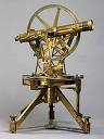
A theodolite is an instrument set on a tripod with an eyepiece that a surveyor looks through to see a point in the distance. It measures both horizontal and vertical angles using triangulation. The first theodolite had circular scales on the outside which were read by the surveyor. By putting cross hairs in the eyepiece, which would look much like the scope on a gun, the early surveyor could get exact readings on a stake or a star. The “hair” used to create this target-like cross was spider silk. The early surveyors would trap a spider and extract some of its silk. Many surveyors found that this silk would last for years without deterioration.

The tellurometer, an electronic distance measuring device (EDM), was popular in the late 1950s and early 1960s. It emits electronic pulses and uses a cathode ray tube (a television) to show the path of the wave. This instrument penetrates haze and mist in daylight and is used for ground surveying where terrain is rough and/or the temperature is extreme. It measures up to 1 km with an accuracy of 0.6 millimetres. Use of this instrument was relatively short-lived as it was very cumbersome and temperamental to use.
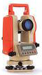
Eventually the theodolite and tellurometer evolved into one instrument called a Total Station - meaning you could calculate and record an angle and a distance at the same time using a single machine. Today, theodolites are digital, just as the one seen in the picture to the left.
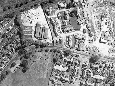
Aerial survey is done by photography that uses infrared, gamma and ultraviolet light. This is done by mounting cameras on the exterior of a plane. The photos provide a wealth of data that is interpreted with complex plotting machines that take the images and draw them on large pieces of paper. This technique greatly increased the surveyor’s scope and eased their task. The photo to the right is an example of what the photographs look like.
Learn more about Field Books - the journals created by early surveyors.