Extension numbers are a land descriptor introduced at the time of conversion. The addition of these extension numbers ensures that all land descriptions are, and will remain, truly unique. New extension numbers are assigned to any parcel changing size or shape as defined on a new plan. These extension numbers are arbitrarily assigned and have no intrinsic meaning.
You are able to determine which portion of land the extension number relates to by viewing the Geographic Information System (GIS) picture of the parcel of land. This parcel picture is available when searching the Land Registry online.
By entering the extension number in your search criteria (e.g.,Search by Land Description), the online Land Registry system will bring back search results for the specific parcel of land (e.g., the portion to the east/west of the roadway) that you are searching.
Evidence of ownership is no longer a “certificate of title” in paper form. Each “ownership register” established under The Land Titles Act, 2000 is for a parcel. By always keeping ownership registers at the parcel level, ISC achieves consistency, ease of interpretation of titles, and the ability to track divided ownership more easily. It is a safeguard against the issuing of titles that collectively represent less than 100% ownership.
To further explain, let's examine a parcel of land, pre- and post- conversion:
Sample Scenario
A quarter section of land (described in the Old Paper-based System as the NE 10-21-15-2) has a roadway running through its centre (see illustrations listed below). Upon conversion to the online Land Registry system, this single parcel is split into three individual parcels, each with its own unique land description.
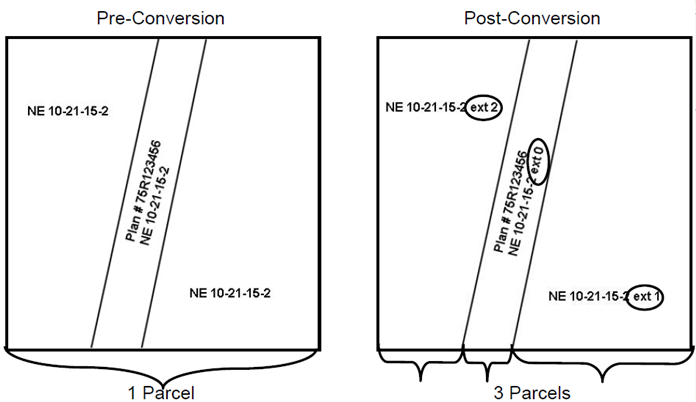
- Parcels in the Old Paper-based System (i.e., preconversion) existed as one title minus any exceptions (e.g., roads, rivers, metes & bounds, etc.). All exceptions were described on a single Certificate of Title.
- Parcels in the online Land Registry system are created for each surveyed piece of land (or, in the case of descriptive plans, the parcel created by the plan). Each lot in an urban subdivision and quarter section in rural subdivisions is a separately surveyed parcel, drawn on the plan individually, and identified with a land description.
- All exceptions (e.g., roadways, railways, rivers, etc.) and metes & bounds will be assigned their
own parcel number and land description.
- All dissected parcels will be assigned their own unique land description (i.e., through the addition of
an extension number to their current land description) and will be tied together by way of a parcel tie. Parcel ties will ensure that one fraction of a parcel is not transferred without the other tied parcels.
- Mineral and surface titles, even if they have the same boundaries, can be dealt with independently.
When Are Extension Numbers Assigned?
Extension numbers were initially assigned to all land descriptions at the time of conversion. Every parcel of land, including those created as a result of parcelization (e.g., the creation of new parcels as a result of metes & bounds and exceptions such as roadways, rivers, railways, etc.) was given its own unique land description.
Metes & bounds descriptions do not exist in the current online Land Registry system. Titles no longer carry forward metes & bounds exceptions. Rather, all metes & bounds are assigned their own plan number and extension number on conversion and become their own parcel (versus an exception to an existing
parcel).
- There are two portions of land associated with a title containing a metes & bounds description.
- The land that is represented by the metes & bounds description (i.e., represented by a plan
number in the online Land Registry system).
- The remainder of the land (i.e., out of which the land represented by the metes & bounds
description is carved).
Since the time of conversion, a new extension number is assigned whenever a parcel of land changes size and shape. This allows for the ability to track a parcel's history from conversion onward.
During the conversion title entry process the convention of setting the extension number equal to the descriptor number was adopted. This guaranteed no duplication of extension numbers for a given old world LLD and eliminated the need for a process to determine the next available extension number for any given land description. This has resulted in “large” extension numbers (i.e., the highest extension number
known is 1189) but was considered acceptable since extension numbers have no intrinsic meaning.
It is a misconception to assume an extension number of zero means a pristine parcel, although it is possible to have two parcels with the same land description and extension numbers of 0 and 1.
Why Do We Need Extension Numbers?
The legal land description (LLD), which is now known as the land description, is a main key in today's online Land Registry system as well as other agencies’ land based systems.
As the size and shape of land changes over time as parcels are dissected, subdivided, consolidated, etc., the land description for these parcels must also be amended to accurately represent the land it describes. The Old Paper-based System documented these changes by simply "describing" them on the certificate of title. The land description was never changed, but rather 'portions' were taken away by means of metes & bounds, etc. This method often resulted in the use one LLD to reference multiple parcels. Scrupulous examination of a certificate of title was required to correctly identify a specific 'portion' of land. The current online Land registry system, on the other hand, has implemented a "unique identifier" system by which all land descriptions will be and remain unique. When the size and shape of any parcel of land is changed the land description that describes it will change also. The online Land Registry extension number serves as this
identifier, ensuring the uniqueness of every land description.
An inactive extension number will serve as a historical record of how that parcel of land once existed. This allows for a truly unique identifier for all parcels of land over time.
Here is an illustration:
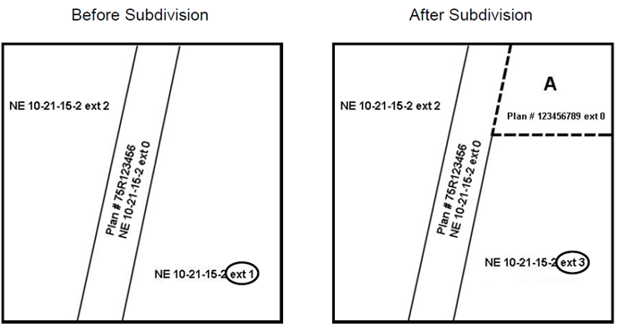
The illustrations above depict how the land description for a parcel of land might change when subdivided. This example has Parcel A being subdivided (by way of a new plan) from the original parcel with the land description NE 10-21-15-2 ext. 1.
Parcel A is assigned a new plan number and land description (i.e., Plan #123456789 ext 0), and the remaining portion of the original parcel (i.e., NE 10-21-15-2 ext. 1) is assigned a new extension number (i.e., NE 10-21-15-2 ext 3), thus preserving the uniqueness of every parcel, past and present.
When a portion is taken from an existing parcel (i.e., by way of a new plan), the remaining portion of the existing parcel retains the land description - only the extension number changes to a new value.
Here is another example:
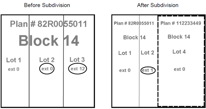
In the example above, a new plan (i.e., Plan # 1122233449) replaces part of an existing plan (i.e., Plan # 82R0055011), affecting two parcels:
- Lot 3 is now replaced entirely by the new plan and no longer exists as an active parcel.
- Its land description (i.e., Plan #82R005501 Blk 14 Lot 3 ext 12) will forever remain as an historical
record of how this parcel once existed.
- Lot 2 is only partially replaced by the new plan (i.e., Plan #112233449).
- The remaining portion of lot 2 will be assigned a new extension number (i.e., ext 1) so that its’ land
description now represents only the current portion of the active parcel (not the portion replaced by the
new plan).
If you have any further questions regarding extension numbers, please contact our Customer Support Team.