The My Plans page enables the PLAN SUBMISSIONS ONLINE user to delete an unsubmitted request, start a new request, or continue on with an existing request or view and archive requests that have been submitted to ISC. New requests can be started by clicking the ‘New Request’ from the My Plans page. Valid ‘Request types’ are:
- Plan Examination
- Support Document
- Plan Resubmission
- Resurrection
- Change Order (ISC staff only)
The PLAN SUBMISSIONS ONLINE application will take the user through the various forms and quality checks, prompting the user for required fields and next steps.
Do I need to submit a CAD file for every request?
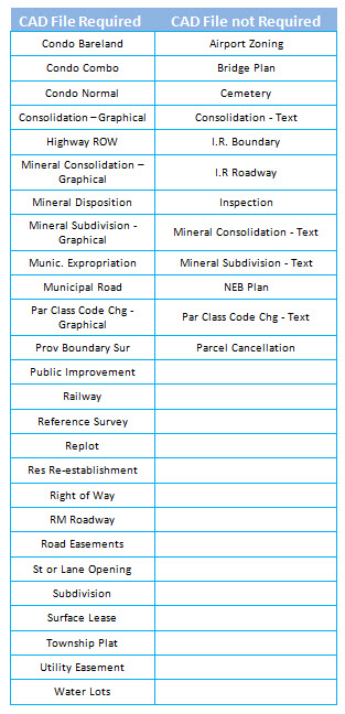
No. Based on the plan request type, the PLAN SUBMISSIONS ONLINE user will be prompted to browse their own system for a CAD file to upload or Drag and Drop a CAD file into the PLAN SUBMISSIONS ONLINE request. Although most plan purposes require a CAD file, some select plan purposes have the option of being uploaded without the CAD file. In instances where a CAD file is not required, the user will enter basic plan information manually or use the drop-down lists.
Where a CAD file is not required, the user still has the ability to upload an optional CAD file with the exception of all text plans. In these instances, none of the plan properties will be extracted from the title block, nor will any of the CAD file quality tests be performed.
The table below outlines plan purposes requiring CAD files:
 What supporting document types are accepted?
Currently only
PDF and
TIF (tif or tiff) document types are accepted.
What CAD file types are accepted?
Currently only AutoCAD
DWG files are accepted. There is no restriction on the version.
I am a surveyor. How do I submit a request for a Change Order?
Create and submit a Support Document request by selecting “Application for Change Order” as the support document. The Plan Number will be required when submitting an Application for Change Order.
How do I submit a request to resurrect a plan that has expired?
Create and submit a Resurrection Request. Select Resurrection as the Request Type when creating a new request. See ISC Policy GO-04/012-Resurrecting Plans or Transform Approval Certificates Through the Plan Index and Tracking System for more information.
When can support documents be added to the request?
Support documents can be added at the Support Documents step of the request. The request cannot be submitted to ISC until the mandatory support documents are attached.
Can I delete plans in My Plans?
If plans have been sent to ISC for approval, you cannot delete the plan however, if plans are a work-in-progress, select the actions menu, then ‘Delete’.
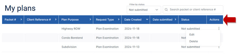 Can I search for plans?
Yes, plans can be searched for by entering a Packet #, or Client Reference # and pressing enter in the search box. The search will be performed against all plan statuses and may be cleared by re-filtering the plan status or pressing the X in the search box.
 Are there special requirements for the support documents or plan images?
Yes – Supporting documents and survey plan images must be in either TIF or PDF format and adhere to the required standards for map border space, plot size, file size and file type. The images do not have to be black and white because PLAN SUBMISSIONS ONLINE will convert the images to 300 dpi Group 4 tiff (which is Black and White) for submission to ISC. Please note that colour images may increase the converted file size significantly.
Map border space (based on 300 DPI file): 20mm to 40mm
Plot Size Maximum (based on 300 DPI file):
860mm by
3000mm
File Size Maximum:
8mb
File Type:
PDF or
TIF (
tif or tiff).
Total Size of all Files being submitted per request Maximum: 16MB
Are PDF Portfolio documents accepted as support documents?
PDF Portfolio documents contain multiple files assembled into an integrated PDF unit. These types of documents are not accepted as support documents. Each PDF file within the PDF Portfolio can be extracted and uploaded as separate support documents.
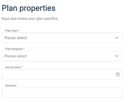
What do I enter in the Plan Properties fields?
Plan Properties are either completed by the PLAN SUBMISSIONS ONLINE user or extracted from the CAD file and reviewed by the user. The data should match what is recorded on the plan to be submitted. PLAN SUBMISSIONS ONLINE extracts the data, but the values can be overwritten by the PLAN SUBMISSIONS ONLINE user. The PLAN SUBMISSIONS ONLINE user is warned to correct their CAD file and corresponding plan image as necessary and upload the corrected drawing to PLAN SUBMISSIONS ONLINE.
Title block information is not extracting automatically?
There are several items to check if the PLAN SUBMISSIONS ONLINE tool is not extracting and populating the Plan Properties fields:
- The CAD text cannot be part of an AutoCAD block.
- The CAD text may exist on layer ISC_TBK in model or the first paper space tab only. PLAN SUBMISSIONS ONLINE will not look at any additional paper space tabs past the first tab.
- The structure and order must adhere to the specification as defined in Appendix C of the Saskatchewan CAD File & Georeferencing Specifications.
Appendix C: Plan Information Layout
Plan information must adhere to this order, and keywords must be used for “By,” “Date,” and “Scale,” as noted below in RED BOLD.
- Plan Type
- Land (GIS) Layer and Plan Purpose
- Reference to affected or subdivided parcels where applicable
- Location
- Surveyor
- Survey Date
- Scale
| Example 1 |
Example 2 |
PLAN OF SURVEY SHOWING
FEATURE RIGHT OF WAY
FOR WATERLINE
THROUGH
PARCEL B, PLAN No. 98SE09839
AND THROUGH
PARCEL U, PLAN No. 101969185
NW 1/4 SEC 21, TWP 13, RGE 5, W2 Mer
KIPLING, SASKATCHEWAN
BY: JOHN DOE, SLS
DATE: OCTOBER, 2012
SCALE: 1:1000 |
Plan of Survey
Showing
SURFACE SUBDIVISION
Of Part Of
N.W. 1/4 Section 7
Twp.16 - Rge.26 –
W.3Mer.
R.M. of FOX VALLEY NO. 171
Saskatchewan
BY: JANE DOE, S.L.S
DATE: November 12, 2010
SCALE: 1:5000 |
- PLAN SUBMISSIONS ONLINE is not able to correctly extract townships or ranges with a suffix of “A” i.e. 45A-26-2. In these particular situations, the user will have to manually enter the “A”. This applies for both quarter locations and corner locations.
- If an AutoCAD file is used for a plan purpose that does not require a CAD file, Plan Submissions Online will not automatically extract title block information. The user will have to manually enter the information. See ‘Do I need to submit a CAD file for every request?’ on page 6.
Does PLAN SUBMISSIONS ONLINE compare the CAD file to the uploaded tiff/pdf plan image?
No – PLAN SUBMISSIONS ONLINE cannot programmatically test that your uploaded CAD is the same as the plan image. The user is responsible for ensuring that the plan image uploaded reflects the CAD file. To assist, the user will be asked to upload a plan image if a new CAD file is uploaded. Additionally, the following message acts as a warning to the user.
My survey was completed over a period of time. What date do I need to use?
Use the latest date of survey.
My survey covers more than one municipality but only one is being extracted automatically. Should I enter the other municipality manually?
Yes – PLAN SUBMISSIONS ONLINE is attempting to extract the title block information but is not always successful. Any anomalies or additions should be corrected or entered by the user.
How do I change information on a previous step?
Select the step from the side navigation and make the changes. Then select “Save Progress.” No changes will be saved unless the “Save Progress” is pressed.
