You can view a Geographic Information System (GIS) picture of the parcel of land to which the title or abstract you are searching refers. The picture is not a plan of survey. It is only an approximate representation of parcel boundaries, dimensions, and area. To determine the actual boundaries, dimensions, or area of any parcel, please refer to
The Land Surveys Act 2000. This picture should not be relied upon for any purpose whatsoever.
NOTE: Some parcels pictures of land are not available. When no parcel picture is available, the View Image icon will not display in the Title Information, Current Title Details, or Current Abstract Details screens. ISC offers a
Parcel Picture on Demand service for customers wishing to view parcel picture that are not currently available,
If the View Image icon does display in those screens, follow the directions below.
You can view a Geographic Information System (GIS) picture of a parcel of land from the Title Information screen or the Current Title Details or Current Abstract Details screen.
- Select the View Image icon from the Title Information screen or the Current Title Details or Current Abstract Details screen.
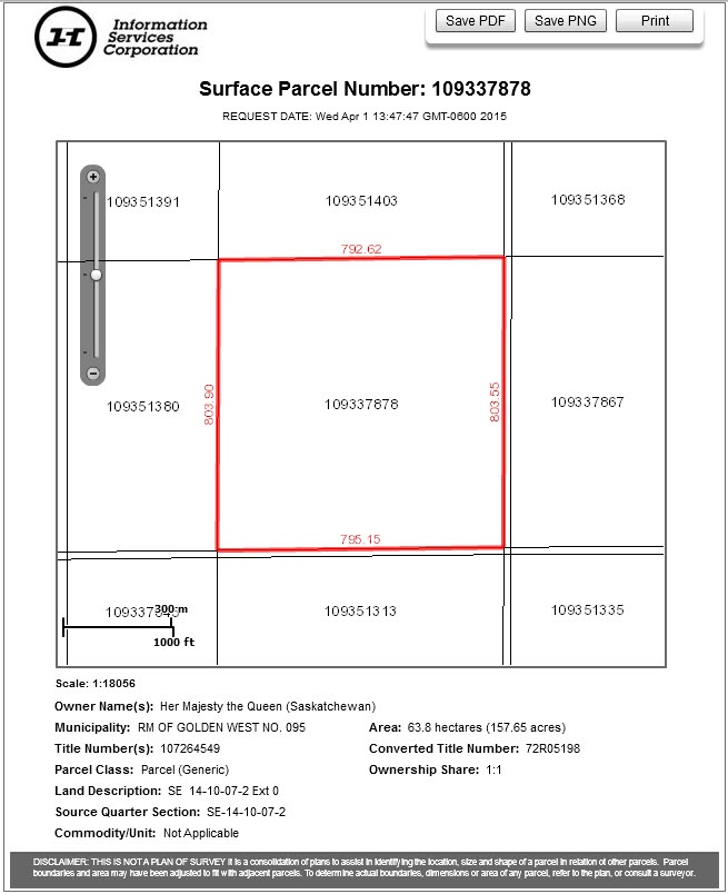
- A picture of the parcel will display with parcel numbers, feature numbers (if applicable), and dimensions.
- Feature numbers are italicized.
- Dimensions are rounded to the hundredth decimal and are displayed in a smaller font.
- The parcel picture opens in a separate window and can be saved and/or printed as desired.
IMPORTANT NOTE: Do not rely on the survey distances given in the parcel picture. Due to conversion problems, these are not always accurate.
NOTES:
- Dimensions are shown when they are available. They are displayed as they appear on the plan of survey.
- Features that are registered on a title may not appear in the parcel picture. As well, features may not be registered on a title but may appear in the parcel picture. You can access information regarding a feature through Search by Feature Number. See the Search by Feature Number section in the Search Help section for more information.
- When the picture of the parcel of land that you are viewing relates to an inactive title, an expiry date will display. The expiry date refers to the day before the title became inactive. In this case, the picture of the parcel of land will be accurate only as of the expiry date.
- The acreage displayed in a parcel picture will be based on GIS calculations and not on the acreage as shown on cancelled paper titles. Acreage information will only be available where the parcel picture is available.